Find Fishing Spots and Map Your Trip with the FishAngler App
Last Updated on January 12, 2022 by Boatsetter Team
When planning a fishing trip to explore a new location, it helps to map out fishing spots and research the weather forecast, water conditions, and which species are biting. Doing so not only increases your chances of catching fish, but it’s also important for safety, especially if fishing from a boat, kayak, or skiff. FishAngler makes planning fishing trips easier with a free app that brings all these capabilities and real-time data to your phone.
Here are the top tips for how to use FishAngler from a boat to land fish and stay safe on the water.
Logged Catches, Fishing Spots, and Fishing Reports
Keeping a logbook helps anglers find repeat success and make improvements on future trips. If knowing where and what you’ve personally used to catch fish is helpful, consider how much more helpful it can be to have data from other anglers to assist you. When fishing in an unfamiliar location or simply looking to learn from others, viewing the map of a body of water on FishAngler will show you the fishing spots where others have logged public catches. Clicking on a logged catch brings up the date of the catch and any photos or additional details noted by the angler who made the catch.
When logging a catch, the app leverages location information from your phone’s GPS or the photo’s location stamp in order to pinpoint catch location and map the date and time of a catch to the historical weather conditions. Anglers can add more information such as fish species, weight, length, bait and gear used, and custom notes. The app makes doing so a breeze with features like a saved inventory of gear and a searchable database of species complete with photos for easy recognition.
If you prefer to keep your fishing spots secret, that’s also an option to set in privacy settings.
Whether you’re headed to an ocean, lake, river, or pond, FishAngler’s map coverage is comprehensive across saltwater and freshwater.

Weather Forecasts and Tidal Charts
Anglers with boating experience know that planning a trip on the water means checking beyond your everyday weather forecast. FishAngler pulls in NOAA data to present you with the following forecasts:
- Wave conditions
- Wind conditions
- Water flow
- Water level
- Tidal predictions
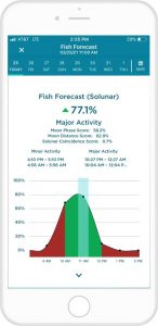
Perhaps best of all, the app shows a fish forecast with times of day that are likely to produce the best fishing activity in a location based on solunar data for any given date.
Locating Buoys
Another safety benefit for boaters exploring new waters is that the FishAngler map includes markers for buoy locations from the NOAA. Buoys are essential navigation aids that direct boaters along safe channels or warn of potential hazards like shallow waters.
There are also markers for USGS inland stations that deliver water forecast data.
Community
FishAngler has grown to be used by over 3 million anglers, connecting fishers locally or across countries and cultures.
Checking out far away locations will give you a realistic sense of what fishing there looks like … and will give you plenty of waters to add to your bucket list. Similar to social apps, you can like and comment on catches and photos to give congratulations and start conversations with people who share a passion for fishing. This focus on social connection helps fishers learn from each other and encourages the fishing community to continue growing.
You can even follow and engage with brands within the app. To follow Boatsetter’s page on FishAngler, go to ‘More’ → Explore Pages → search ‘Boatsetter’.
Ready to plan your next fishing adventure?
Rent a fishing boat or find a fishing charter here on the Boatsetter website or in our app (for iOS or Android), and bring along the FishAngler app to fish smarter and boat safely.
Click either app icon below to download FishAngler.

Boatsetter empowers people to explore with confidence by showing them a world of possibility on the water. Rent a boat, list your boat, or become a Boatsetter captain today.
